If you are searching for a home on "boatable water" in Bradenton, the biggest question is not whether the listing sounds impressive. It is whether you can actually use the water the way you want to. For many buyers, that means looking beyond the view to understand access, permits, flood risk, and day-to-day upkeep. This guide will help you sort through what matters most before you buy. Let’s dive in.
What "boatable water" means
In Bradenton, "boatable water" is more of a practical real estate term than a formal legal one. Local rules focus on things like docks, seawalls, floodplain management, manatee protection zones, and submerged-land use, not on a specific legal definition of boatable water. In plain terms, it usually means the property offers usable boat access rather than just waterfront scenery.
Whether a property is truly boat-friendly depends on several factors. Water depth, tides, bridge clearance, speed zones, and the route to open water all matter. According to Manatee County environmental review guidance, access can vary widely even among homes that appear similar in marketing photos.
Bradenton's location makes these details especially important. The area connects to the Manatee River, Tampa Bay, Sarasota Bay, the Intracoastal Waterway, and mainland routes toward Anna Maria Island. The Florida Coastal Access Guide for Manatee County also notes drawbridges in the area, which can affect travel time and convenience on the water.
Compare Bradenton waterfront types
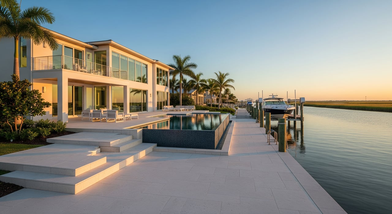
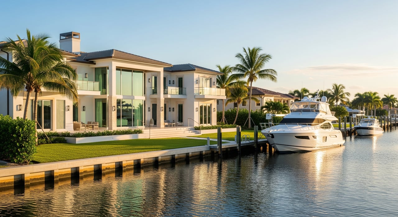
Not all waterfront in Bradenton offers the same boating experience. Before you fall in love with a lot or a dock, it helps to understand what kind of water frontage you are actually buying.
Tidal saltwater frontage
This category usually includes access tied to the Manatee River, Tampa Bay, Sarasota Bay, or the Intracoastal Waterway. These locations can offer the kind of boating lifestyle many buyers picture, but route planning still matters.
For example, Manatee County's paddling guide notes that Sarasota Bay is relatively shallow, with an average depth of about five feet. That means draft, tides, and your boat type can make a big difference in how useful a property really is.
Sheltered canals and backwaters
Canal-front homes often appeal to buyers who want calmer water and some protection from wind and chop. They can feel easier for docking and more comfortable for everyday use.
Still, sheltered does not always mean simple. The same county guide warns that some routes may become shallow or even impassable at low tide, and bridge currents can be strong in certain areas. A calm canal lot can still come with access limitations once you leave the dock.
Freshwater frontage
Freshwater properties are a different category altogether. The Braden River and Evers Reservoir area, for example, may work well for smaller boats, paddling, and fishing.
That said, freshwater access is not the same as direct saltwater-to-Gulf access. County guidance on the Braden River area makes that distinction clear, so buyers should match the property to how they actually plan to use the water.
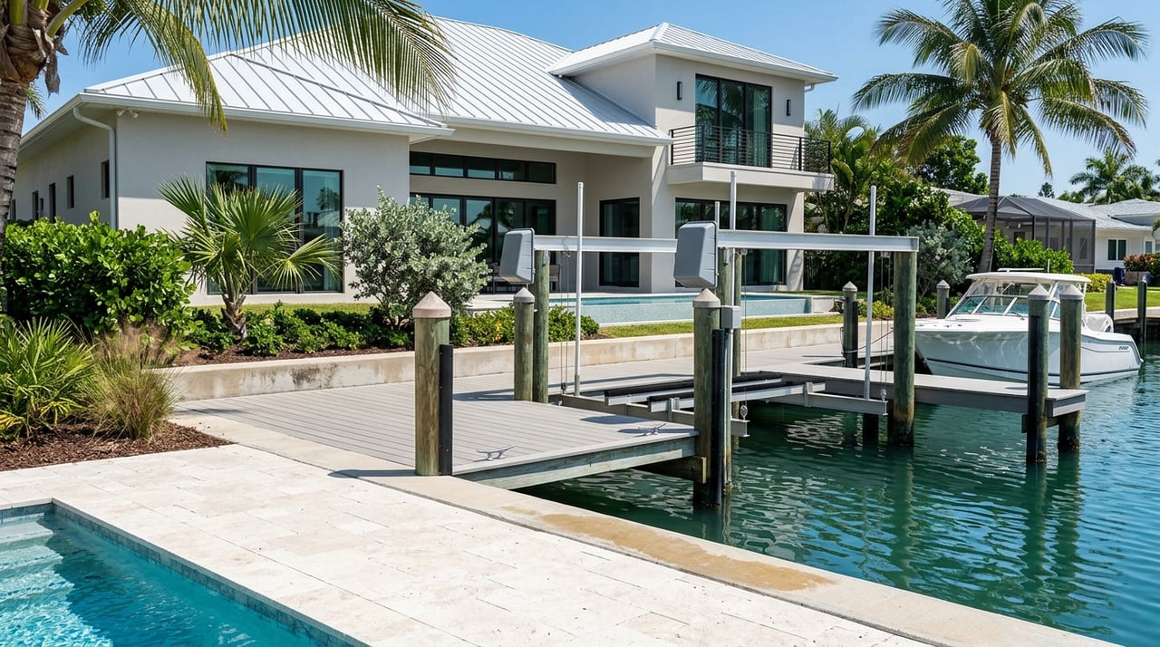
Check docks and shoreline permits
A dock can be a major selling point, but it should also be one of the first things you verify. In Manatee County, waterfront structures like docks, seawalls, and rip rap are regulated under Land Development Code Section 511.17.
The county explains that waterfront or erosion-control structures generally should not be erected, expanded, or reconstructed without an administrative permit. Some projects may also require separate approvals from the Army Corps of Engineers, the Florida Department of Environmental Protection, and the Southwest Florida Water Management District, according to Manatee County's waterfront permitting information.
This matters because a dock is not just a feature. It is part of the ownership cost and part of the property's long-term marketability. If a structure was not properly permitted, or if rebuilding after storm damage would be difficult, that can affect both your enjoyment and future resale.
Why submerged-land issues matter
In some cases, a dock or lift may involve sovereignty submerged lands. The Florida Department of Environmental Protection submerged lands program explains that these lands generally include areas waterward of the ordinary or mean high water line beneath navigable or tidally influenced waters.
For buyers, the practical takeaway is simple: ask whether a submerged-land lease applies and whether any related obligations or fees are in place. This is especially important if the property includes an existing dock, lift, or other waterfront improvements.
Understand flood and stormwater risk
Living on the water in Bradenton can be rewarding, but it also comes with extra planning. Floodplain rules, elevation, storm surge exposure, and drainage are all part of the ownership picture.
The City of Bradenton explains in its floodplain materials that communities in the National Flood Insurance Program adopt floodplain rules to reduce damage. The official source for public flood hazard information is FEMA's Flood Map Service Center, which buyers should review before writing an offer.
The city also offers a real-world example through Lift Station 8, which sits next to the Manatee River and below FEMA base flood elevation. That local example is a useful reminder that waterfront and water-adjacent infrastructure can be vulnerable during heavy rain and high tides.
Daily ownership on the water
Stormwater and water quality rules affect daily life more than many buyers expect. Bradenton's stormwater guidance says that discharges to the drainage system or waterways that are not entirely stormwater are prohibited.
In practical terms, that means waterfront owners need to pay close attention to runoff, debris, yard waste, and cleaning practices. After storms, that can translate into more maintenance and cleanup than you might see at an inland property.
Learn the boating route first
One of the smartest things you can do before buying is trace the route from the dock to the water you actually want to use. A home may sit on the water, but that does not automatically mean easy or efficient boating.
You will want to confirm whether the route is tidal or freshwater, whether low tide creates limitations, and whether the path leads to the Manatee River, Sarasota Bay, Tampa Bay, or only to a smaller canal or basin. Manatee County's paddling and waterway guide is a helpful starting point for understanding those conditions.
Watch for bridge and speed limits
Local boating is also shaped by bridge conditions, no-wake areas, and protected zones. The county notes that designated slow-speed areas and signage are used to protect manatees and improve safety.
You can review these considerations through Manatee County's manatee protection zones information. If your goal is quick access for frequent outings, even a short route can feel longer when bridge openings, speed zones, or shallow sections are part of the trip.
Use a buyer checklist
Before you move forward on a boat-friendly home in Bradenton, keep this checklist in mind:
- Verify where the route actually goes and whether it is usable for your boat type.
- Confirm the permit status and age of the dock, lift, seawall, and rip rap.
- Ask whether a submerged-land lease applies to any waterfront improvements.
- Review flood maps, elevation, and likely insurance implications before making an offer.
- Check bridge clearance, no-wake areas, and manatee protection zones on the route.
- Plan for ongoing maintenance, including dock condition, seawall upkeep, runoff management, and storm cleanup.
- Use local guides carefully and confirm navigation details with the appropriate charts. The Manatee County boater's guide specifically says it should not be used for navigational purposes.
The bottom line on boatable homes
In Bradenton, a home advertised as boatable should be evaluated on more than the label. The key questions are whether the water access is legal, navigable, maintained, and affordable to own over time.
The strongest candidates are usually properties where the route fits your boat, the dock and shoreline improvements are properly documented, and the flood and maintenance profile is clear before closing. If you want help comparing waterfront options in Bradenton and understanding how they align with your goals, connect with Smith Garcia Group.
FAQs
What does boatable water mean for a home in Bradenton?
- In Bradenton, boatable water usually means usable boat access, but the real answer depends on depth, tides, bridge clearance, speed zones, and whether the route reaches the water you want to use.
What should you verify about a Bradenton dock before buying?
- You should confirm whether the dock, lift, seawall, and related improvements were properly permitted, how old they are, and what approvals may be needed if they are damaged or replaced.
How do flood maps affect a waterfront home purchase in Bradenton?
- Flood maps help you understand flood zone status, risk exposure, and possible insurance implications, which can affect both monthly costs and long-term ownership planning.
Are all waterfront homes in Bradenton suitable for Gulf access?
- No. Some homes connect to tidal saltwater routes, some sit on canals with low-tide limits, and some are on freshwater frontage that does not offer direct saltwater-to-Gulf access.
Why do manatee zones and bridge clearance matter for Bradenton boaters?
- These factors can affect how quickly, safely, and easily you can leave the dock, especially if your route includes slow-speed areas, shallow water, or bridges that change timing and clearance.